
A geostatistical downscaling and integration approach is developed, accounting for the differences in spatial resolution between the available NWP and SAR data, as well as adjusting for inherent mismatches and uncertainties. In the first step of the methodology, area-to-point (ATP) kriging is applied to obtain downscaled wind estimates at 1km spatial resolution from NWP coarse data (11 km resolution) while preserving the characteristics of the original wind product.
Flowchart of ATPKED Spatial Downscaling Algorithm
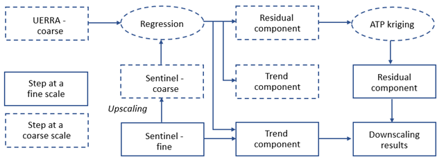
The aim of this downscaling step is to compare the wind estimates with Sentinel-1 SAR data so as to facilitate both data integration and adjustment of mismatches at a finer spatial resolution. In the next step, the downscaled wind estimates are integrated with the SAR data using multivariate kriging. Sensitivity analysis is also conducted by incorporating the mismatches between both data sources against wind data obtained from coastal meteorological stations. The uncertainty of the final downscaling predictions is assessed within a geostatistical stochastic simulation (spatial Monte Carlo) framework: multiple simulated downscaled wind fields are generated from the NWP data for a particular time, and each of those fields is integrated with the SAR data via multivariate kriging to compute the final simulated wind predictions; the discrepancies between the multiple simulated downscaled/fused predictions is used to quantify the uncertainty of final wind estimates at the fine (500m) resolution.